Call us now :07313726874
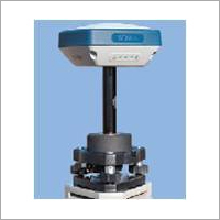
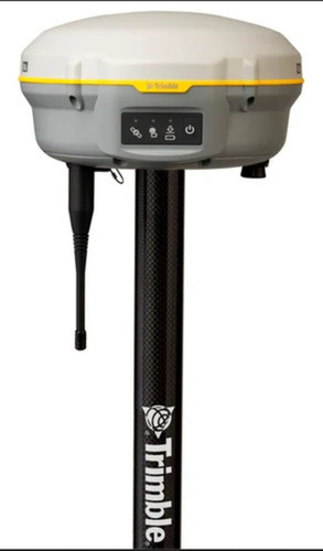
DGPS Surveying Instrument
Product Details:
- Frequency 50-60 Hertz (HZ)
- Usage Road surveyor
- Material Metal & Plastic
- Size Standard
- Display Type Digital Only
- Click to View more
X
DGPS Surveying Instrument Price And Quantity
- 1 Unit
DGPS Surveying Instrument Product Specifications
- Metal & Plastic
- Road surveyor
- Digital Only
- Standard
- 50-60 Hertz (HZ)
DGPS Surveying Instrument Trade Information
- Cash in Advance (CID)
- 50 Unit Per Month
- 1 Week
- Yes
- Contact us for information regarding our sample policy
- Packing in carton boxes.
- Australia, North America, Eastern Europe, Western Europe, Central America, Middle East, South America, Asia, Africa
- All India
Product Description
Channel: independent 226channels, Tracking signal: L1/L2
Static horizontal accuracy: 3mm+1ppm
Static vertical accuracy: 10mm+1ppm
RTK horizontal accuracy: 10mm+1ppm
RTK vertical accuracy: 20mm+1ppm
Static operation range<=80km
Communication: USB2.0 / COM Port RS-232
Enhanced Survey Accuracy with DGPS Technology
DGPS Surveying Instruments utilize real-time corrections from a fixed location to deliver highly accurate geographic coordinates. By eliminating common GPS errors, this technology is especially valuable for applications demanding rigorous precision, such as road construction and mapping projects. Users benefit from seamless digital data readouts and dependable operation in the field.
Designed for Practicality and Durability
Featuring a robust construction from both metal and plastic, this instrument balances durability with lightweight convenience. Its standard size and manageable weight (100500 grams) make it easy to handle and transport across remote or urban survey sites. The blue color adds visibility, and its digital display ensures all essential readings are clear and precise.
FAQs of DGPS Surveying Instrument:
Q: How does the DGPS Surveying Instrument enhance surveying accuracy?
A: The DGPS Surveying Instrument uses a fixed base station to correct GPS signals in real time, compensating for pseudorange errors and providing highly accurate geographic data. This enhances measurement precision, crucial in road and infrastructure surveys.Q: What applications is the DGPS Surveying Instrument suitable for?
A: This instrument is primarily used for road surveying, but it can also be employed in other civil engineering, geospatial mapping, and construction projects where accurate positioning is required.Q: When should I use a DGPS Surveying Instrument instead of a standard GPS device?
A: A DGPS Surveying Instrument should be used when your project requires higher accuracy than standard GPS can provide, especially in applications like road construction or engineering surveys where precise data is critical.Q: Where can the DGPS Surveying Instrument be used?
A: The instrument is designed for use at various outdoor sites across India, including roadways, construction areas, and open fields where accurate surveying is needed.Q: What is the process of using this DGPS Surveying Instrument in the field?
A: Set up the instrument at your survey site, ensuring the fixed base has a known position. Power the device using a standard 220V supply, initiate the digital display, and then capture location data. The instrument will automatically correct GPS signal errors in real time.Q: What are the main benefits of using this DGPS Surveying Instrument?
A: Users gain access to precise location data, minimizing errors commonly associated with traditional GPS. The lightweight yet durable build, digital display, and reliable power supply make it a practical choice for demanding fieldwork.Q: How should the DGPS Surveying Instrument be maintained for optimal performance?
A: Keep the instrument clean, avoid exposure to extreme temperatures, and store it carefully when not in use. Regularly verify that the digital display and correction functions are operating correctly to ensure long-term accuracy.Tell us about your requirement

Price:
Quantity
Select Unit
- 50
- 100
- 200
- 250
- 500
- 1000+
Additional detail
Mobile number
Email

Other Products in 'Gnss Receivers' category
Our Products
- Road Survey Equipment
- Gnss Receivers
- Surveying Equipment
- Surveying Total Stations
- Leica Flexline Manual Total Stations
- Leica iCON Total Stations
- Leica Captivate Total Stations
- Leica Viva Total Stations
- Leica Nova Total Stations
- Leica Detail Kits
- Leica Total Station Controllers
- Leica Traverse Kits
- Total Station Accessories


WZ 76, 2ND FLOOR, TITARPUR, TAGORE GARDEN,New Delhi - 110059, India

Mr. Sunil
(Marketing Head)
Mobile :07313726874
Mr. Varun Kumar
(Director)
Mobile :07313726874
 Send Inquiry
 Send SMS
 Call Me Free
Developed and Managed by Infocom Network Private Limited.
